
How rural poor populations fared in Pakistan’s 2022 floods
Widespread and prolonged flooding in Pakistan in 2022 had devastating consequences, with evacuation being far from universal and low rates of permanent migration.
On 27 July 2022, Pakistan’s Meteorological Department signalled the end of the monsoon season in Sindh, the south-easterly province of the country. Their forecast predicted a weakening of the ongoing monsoon by the end of the month, and its shift towards the north.
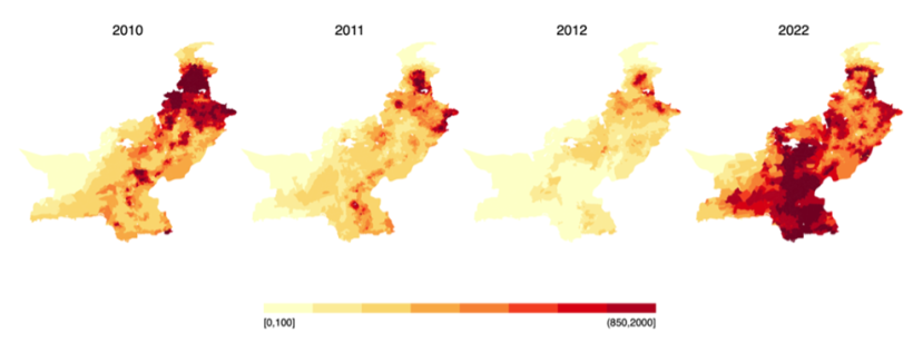
Within two weeks of this announcement, however, unprecedented rains lashed the province, more than 500% above Sindh’s 20-year average. The rains resulted in the worst flooding in Pakistan’s 70-year history – Sindh endured nearly twice the amount of rain it witnessed during the 2010 floods, previously the nation’s most severe (Figure 1).
Figure 1: Floods in 2022 compared to the biggest floods in Pakistan’s history
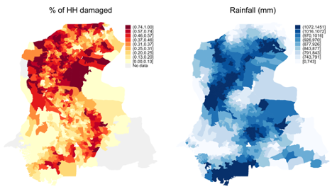
These floods disrupted the lives of millions and caused widespread damage. A Post-Disaster Needs Assessment valued total economic damages at US$ 14.9 billion. An estimated 70% of these were believed to have occurred in Sindh. The maps (Figure 2) below use administrative data on damages and satellite measures of rainfall to show how rain intensity tracks the spread of housing damages in Sindh.
Figure 2: Percentage of households damaged versus spatial pattern of rainfall
Understanding the impact of floods on rural households of Sindh
We take a closer look at how the rural poor populations in Sindh were impacted by this major extreme weather event. We had access to pre-flood administrative data of the location, occupation, education levels, and asset holdings of all rural poor households in six districts of Sindh (Tando Allahyar, Tando Muhammad Khan, Matiari, Sujawal, Larkana, and Kamber Shahdadkot). We randomly sampled 5,100 households from these districts – taking special care to cover the full spectrum of flood intensity within them – and surveyed the sampled households one year after the floods.
Households in our study are exclusively rural. They mainly relied on agricultural work or off-farm manual labour to make ends meet. They are also mostly poor, sampled from both sides of the eligibility cutoff for the largest cash transfer programme in Pakistan. Thus, by design, 50% of the households in our study were eligible for social protection before the floods, and the median monthly household income was PKR 15,000 (US$ 54).
We describe below our descriptive findings from the first survey wave but, first, a note of caution: we do not report causal effects here, which will be covered in the future, along with findings from additional rounds of follow-up surveys.
The debilitating effects of flooding and response barriers
Flooding was not only severe, but also incredibly prolonged. Floods disrupted lives long after the monsoon was over. Water depth at the peak of the floods was 2.9 feet but was reported to be as high as 7 feet in some areas. Since Sindh is largely low-lying and flat, these flood waters were slow to drain. As a result, on average, the floods lasted 74 days and led to 24 days of displacement. However, some regions experienced up to seven months of inundation and displacement. Places outside the village people go to for purchase or sale of goods, work or education remained inaccessible by road for a month on average, and up to three months.
The consequences were devastating: in our survey, 95% of households reported some damage to their residential properties, while about half reported that their homes were fully washed away. In addition, 89% reported that at least one household member fell sick due to the floods.
Despite all households in our sample experiencing some degree of flooding, evacuation was far from universal. Only 41% of households evacuated and went to places that were on average only 6 km from their residence. In line with this, respondents also estimated that while most households in their village (61%) were flooded, only 31% evacuated. Amongst those who did not evacuate, 56% reported that they preferred to stay to ensure the security of their house or land, underscoring the high levels of land insecurity in the region (76% of our households do not own a formal land title deed). Another 26% reported having nowhere to go, highlighting the widespread inundation around them, as well as the spatial concentration of their social networks. This suggests that merely providing early flood warnings may be ineffective if households face systemic barriers to moving out of harm’s way.
Though the floods caused immense destruction and sizable displacement, permanent migration was not a major response to this shock. We found 88% of households in or around their pre-flood location, and only 1% of our sampled households were known to have migrated after the floods; other households that weren’t found were considered by locals to be data entry errors in administrative records, temporarily absent, or had migrated in the five years prior to the floods.
The low rates of permanent migration raise important questions about how these decisions may have been influenced by the suite of large, place-based reconstruction programmes being launched by the state in response to the floods. We study the relationship between private adaptation and publicly funded place-based reconstruction in our follow-up work.